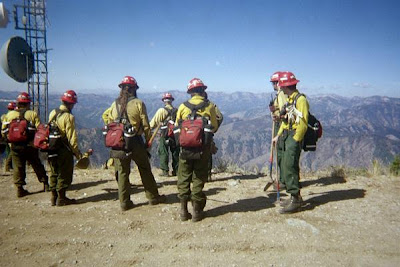
As I type this, many of my compatriots and thousands of wild land forest fire fighters are scourging through the thick of the forest displacing the immense heat with axes and shovels. Their job is dangerous; people die every year fighting forest fires. The heat from a forest fire is so great that it can literally boil the soil days after the fire has burned through. The heat drives deep within the ground where it can stay burning hot for months. This type of heat is so hot that if you poured water on it, the water would only sit on top of it and evaporate, not affecting the heat at all. These pits of fire exist under the ground waiting for the right wind to blow, or the right root to run on, called root fires, and can easily re-ignite a forest fire.
Firefighters Go Where Machines Can Not
Send in wild land forest fires. After they dig a line around a fire it’s time to attack the “black”. The “black” is the name of the part of the fire that has already been burned over. Gridding the “Black” for hotspots is an extensive part of putting out a wildfire. The firefighters line up spread out every five yards, twenty people long, and start gridding the forest. Their job is to find any of these hot spots, and so far the methods of finding the heat are the same as firefighters starting fighting wild land fires a hundred years ago. They look for smoke(duh), smell for fire, look for bugs on the surface (some bugs are attracted to heat), but the main method of locating underground hot spots that can easily reignite a forest fire is by sticking the top of their hands into the ground every square foot in the woods. If their hand gets burned, then they know that there is heat there that needs to be dug up and displaced. The proper method of feeling the ground for heat is to use the topside of the hand, that way, when they get scolded by the heat and blistered, the working part of the hand is not blistered and they're still able to hold a shovel. Sounds archaic, it is. It’s high time we arm our firefighting army.
Thermal Imaging Technology
There is a chain of command that is like the military on a fire fighting crew. One of the higher up fire authorities, who is like a commander, walks around the “black” using an expensive thermal imaging system. With this machine he sees the hotspots burning within the ground. He then marks the hotspot with a ribbon tied on a branch of a nearby tree for the firefighter crews to find. If this commander happens to run into the firefighter crew in the vicinity he’ll point and give vague forest directions like, “that way about a hundred yards”. The crew’s then trek through the extremely dangerous forest looking for ribbons tied to trees. Nearby a pink ribbon tied to a tree, there will be a hotspot.
GPS and Fire Crews
Recently though by the motivation of those firefighters and backpackers who love to have the latest woodland gadgets, fire crews have guys armed with GPS satellite mapping and location devices. Now, instead of looking for pink ribbons in a burnt out smoking forest, the crew can receive exact coordinates of the hotspots overlaid pinpoint accurate topographical maps. The future of GPS technology could look like this; a passing satellite takes thermal readings of a forest fire and emails the crew bosses (sergeants) the map with the coordinates of the hotspots along with other imperative weather information. Or the commander’s thermal imaging gun can transmit the coordinates of the hotspots directly to the crew bosses GPS unit using Bluetooth technology. The crews can then easily locate the coordinates of the hotspots and put them out. Much less time spent sticking their hands in the forest floor blindly not knowing if a snake lies in wait in that hole or if super heated burning coals will scold and blister their hands. GPS systems also offers important fire information such as current elevation, weather updates, and other fire hazards like dangerous deadly tree and bee hives could be marked on the map. GPS will also let the Incident Commanders (president) know exactly where the crews are on the fire all the time and in real time. Some of the Unites States tragic deadly wild fires were incidents in which the Incident command did not know where the fire fighters were on the fire.
Forest fires put forest fire fighters in the back country and in perilous conditions; one change in wind direction can scramble a team. The fire fighters must be armed with the information, maps, and location technology to safely put out these ginormous threats to our society. Communication from the top of the command structure to the guys in the black must be concise, informative, and in real time; there is no room for error and no reason any forest fire fighter should be left unarmed and unaware.
Mark Stegman
0 comments:
Post a Comment
Subscribe to:
Post Comments (Atom)


